 |
| Map Showing 4066 Highway from PYN NEWS |
The 4066 highway is one of the most important strategic development of modern Thai government in the south of Thailand, The 4066 highway is about 28+485.968 Kilometers started from Talohalo(Telok Halo) village in Raman district, province of Yala and end up at Palobatas(Kepala Batas) village in Nyingo district, province of Narathiwat. It is the connection between Yala province and Narathiwat province on the shortest rout, which can reduce the journey about 40 kilometers from the all available old routs in the area.
Budo mountain range or Bukit Budo in Malay language is famous for its beauty, natural resources enrichment, sharing great events in the history of the area as well as famous for the war of Patani Malay defense and liberation against Siamese invader.
Budo Mountain is part of Sankala Kiri range lie as the back bone of southern Thailand, in some area lie through difference districts of Yala province such as Betong, Yaha, Bannang satar, Thanto, Raman and many districts in Narathiwat province such as Bacho, Nyingo, Waeng, Sungaikolok, Sukirin including some districts in Patani province such as Thungyangdeang, Kapo, Saiburi.
The original project of 4066 highway Talohaloa(Telok Halo)-Palobatas(Kepala Batas) started in 2004 and will completed in 2006, the project has extended the duration for 5 times due to the unrest situation and land payment problem of the villagers, in 2009 the Democrat government passed the construction of the site to the Thai army in place of Private construction company and in 2011, the project is completed by the army which using the total duration for 8 years for 28+485.968 Kilometers long.
Short Cut and Beautiful Scenario
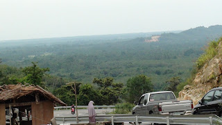
This 4066 highway is run from west at Talohalo intersection , Raman district, Yala province to the east end up at Palobatas connected with high way 42, Nyingo district, Narathiwat province. This 4066 highway run through the Budo mountain range at its highest point of 200 Meters from the sea level, from this point of resting area every one can see a beautiful part of the flat area of Narathiwat province, the coastal area of gulf of Thailand and the greenery of rubber and palm plantation of Narathiwat province beside, a beautiful stream is available at this resting point area which every one can enjoy bathing from natural water flow down from Budo mountain, the water is clean, fresh with natural aroma.
Strategic Highway
The 4066 Highway is very important for the connection of the two provinces of Yala and Narathiwat in term of convenience and duration of journey because its become shorter than the most convenient old routs about40 kilometers but the unrest situation become an important hindrance to the popularity of the highway itself. The Budo mountain is well known on it prestige associated with the unrest or liberation events for more than 200 years since Patani was annexed by Siam
The 4066 Highway is very important for the connection of the two provinces of Yala and Narathiwat in term of convenience and duration of journey because its become shorter than the most convenient old routs about
Since the Malay villages are every where at the foot of the Budo mountain, then the relationship between the separatists and the villagers are always in the “focus alert” of the Thai government, this ‘focus alert’ had become the all time important humanitarian issue of the Thai government and 4066 highway is one of the best tool of the Thai government to die down the support of separatist movement among the villagers who live scattered at the foot hill of the legendary Bukit Budo.
 |
| The Over All 12 Meters Wide of 4066 Highway |
 Labels:
Travel and Study


 Previous Article


Responses
0 Respones to "Drive through 4066 Highway(Talohaloa-Palo Batas)"
Post a Comment